GUEST POST by Carol Devine
APECS member and co-author of The Antarctic Book of Cooking and Cleaning
Antarctica, like the Arctic, is a harbinger. It holds the majority of the world’s water and ice, and is crucial to the global ecosystem. People first began exploring this ‘last continent’ at the turn of the 20th century, so Antarctic science is only about 100 years old. But this windiest, highest, coldest and driest continent holds ancient information, invaluable today for climate change studies. With the Southern Ocean warming rapidly, investigating how conditions have changed in the past is important, and magnets are a vital tool for this research.
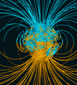
Magnetic material is everywhere: in soil, in fish cells, in computers, in us. The world’s largest electromagnet is the planet itself, with a magnetic field generated by electric currents in the Earth’s spinning molten iron core. Like all magnets, the Earth has north and south poles. But the magnetic field is tilted so the magnetic poles, the ones a compass needle points to, are not in the same place as geographic poles. And those magnetic poles are constantly drifting. According to the British Geological Society (BGS) the angle between true north and magnetic north, known as declination, was one of the first variables measured over the earth’s surface.
From the beginning, magnetism has been one of the main attractions for polar explorers. A meeting of the British Association for the Advancement of Science in 1838 resolved that the coverage of magnetic measurement in the southern hemisphere had to be improved, setting off the so-called Magnetic Crusade. The goal was to understand the cause of the Earth’s magnetic variation.
Early explorers and scientists like Robert Falcon Scott’s National Antarctic Expedition in 1901–04 and the British Antarctic Expedition in 1910–13 went south for the sake of knowledge, empire and to locate the Magnetic South Pole. During frigid, sunless days they risked their lives hauling laden sledges across icy wastes. They collected penguin eggs to study evolution and recorded meteorological, geographic, biological and especially magnetic observations to build our understanding of Antarctic science and the Earth.
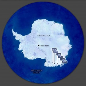
These expeditions helped pin down the location of the magnetic pole in 1909, but although locating and plotting the south pole was an important research area on its own, it is the study of how the magnetic field has affected the earth, recorded in magnetic remanence-acquiring minerals, like iron oxides and sulphides, that have helped reveal changing climate conditions.
Magnetic rocks and formations act as sensitive recorders of climate, allowing us to investigate climate variables giving insight into trends over thousands of years. In Antarctica today, geologists working with paleomagnetism laboratories drill the Ross Sea floor to extract rock cores. They analyze changes in magnetic properties and magnetization recorded in iron-bearing sedimentary rocks they retrieve from the sea floor which were deposited some 20 million years ago. The size, composition and concentration of magnetic materials (as well as the ancient flora and fauna in the rock fossil cores) tell us about environmental and climate changes through time. The presence of certain magnetic minerals can indicate glacial and interglacial periods. The rocks also give scientists direct evidence of the past position of the continent’s north-south position by measuring locations of remnant magnetic materials.
From driving exploration and scientific expeditions, to serving as recorders of climatic patterns, magnets have formed part of the foundation of what we know about the Antarctic continent, and are important tools for continued studies in paleomagnetism, paleoclimatology, paleobiogeography, and the geological history of the earth systems over both the short-term changing climate, and the long-term wandering magnetic poles.
Supplement:- Where are the magnetic poles?
The National Earth Science Teachers Association “Windows to The Universe” program says that in 2005, the North Magnetic Pole was about 810 km from the Geographic North Pole, in the Arctic Ocean north of Canada. In 2005 the South Magnetic Pole was about 2,826 km from the Geographic South Pole, off the coast of Antarctica in the direction of Australia.

Position of the magnetic south pole since it was first located in 1909 (image from Terra: The Encyclopedia of New Zealand).

Eric Webb, Chief Magnetician, in the Magnetometer Hut, Australasian Antarctic Expedition (1911-1914) (Photographer: unknown; public domain).

The Magnetograph House, with Dr. Frank Leslie Stillwell, geologist with Australasian Antarctic Expedition (1914-1914), standing on the north face (Photo: Frank Hurley; public domain).

Computer simulation of the Earth’s field in a period of normal polarity between reversals created by Dr. Gary A. Glatzmaier, Los Alamos National Laboratory, US Department of Energy. The lines represent magnetic field lines: blue when the field points towards the center and yellow when away (Wikipedia commons).


